
Editor’s Note: This is part of a series of dispatches from the Knight Science Journalism Program’s 2020-21 Project Fellows.
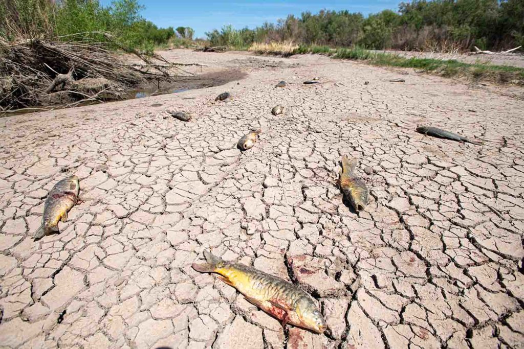
It’s called the “hardest working river in the West.” By the time the Colorado River runs its 1,450-mile course, every drop of water is diverted and used by two countries, seven U.S. states and 40 million people, from Wyoming to Mexico. Its historic terminus in Mexico’s Gulf of California is now a mosaic of dry river channels, and mineral and salt deposits. From the air it looks like a cross-section of an enormous animal with arteries spaced by multi-colored mounds of tidal mud. It’s beautiful and terrible at once; the corpse of the once verdant Colorado River Delta.
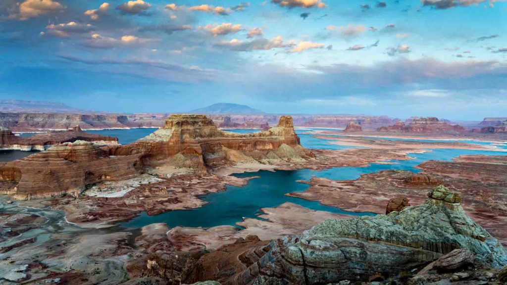
I was raised in California and now live in Colorado, two states utterly dependent on the river but in very different ways. I’ve long been fascinated by how this river’s water is managed and allocated, how seven states and the U.S government support one of the most complex water systems in the world to make the arid Southwest habitable and profitable. But this system is facing a reckoning. A prolonged drought in the Southwest, climate change, and increasing demand have water managers scrambling for answers. How do you sustain a system with year-on-year water deficits? Who gets less water and in what order? Will the main Colorado River reservoirs in the system, Utah’s Lake Powell and Nevada’s Lake Mead, fail?
With this uncertain future as a driver, I hit the road to photograph “the system”, from Wyoming to Mexico. But in the pandemic, this was not going to be travel as usual. I bought a truck camper to create a travel bubble for myself and a drone that I learned to fly, since aerials from planes were now off the table. Until I was vaccinated, I couldn’t shoot people stories, the hardest sacrifice for a photojournalist. Instead, I set out on a landscape and infrastructure mission.
The Colorado River system is divided into two basins. Colorado, Wyoming, Utah, and New Mexico are in the Upper Basin, and Arizona, Nevada, and California are in the Lower Basin. The Colorado River Compact of 1922 divides the water equally between the basins, each allotted 7.5 million acre-feet per year. The Upper Basin is required to deliver 9 million acre-feet of water to the Lower Basin annually (including 1.5 million acre-feet to Mexico), measured below the Glen Canyon Dam at Lee’s Ferry, Arizona. Sounds simple enough, but like any facts used to simplify a complex system, actually diverting this water to the states is a mind-boggling endeavor. Now, with the Colorado River shrinking, all compact states are facing mandatory cutbacks in their water allocations.
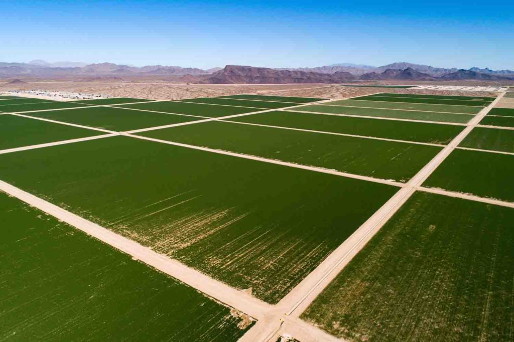
Of all the basin states, Arizona is the most transformed by and dependent on Colorado River water. The state takes its river water from Lake Havasu and transports it via canal 336 miles through Phoenix, through thousands of acres of desert turned farmland, and into Tucson. Known as the Central Arizona Project, this conveyance of Colorado River water is the artery responsible for the Arizona we know today. Without it, large sections of the state would return to desert and the cities would whither. To offset any cutbacks that could come with shrinking river water supplies, the state is banking on its underground aquifer to fill the need.
I was thinking about this odd bargain with groundwater as I headed to a large corporate farm in La Paz County in far western Arizona, a hardscrabble desert region with no surface water to speak of. Arizona differs from most states in that its groundwater in many rural areas is not regulated. Large corporate farms were taking advantage of this by pumping as much water as they wanted, for free. I was looking for Fondomonte, the controversial Saudi-owned hay operation, without realizing I had been driving through the farm for five minutes. It’s sheer size in such an arid place was hard to comprehend. With the free, unlimited groundwater, it irrigates 10,000 acres of hay, which is then shipped back to Saudi Arabia as cattle feed. The Saudis aren’t stupid. They know the value of water. But I had to wonder if Arizona did.
And this is the rub. No one wants things to change, though they all know water is changing. The fever to grow grips cities like Phoenix, Las Vegas and St. George, Utah, and even though I knew there are smart, concerned scientists, policy makers, and water managers trying to plan a future for the Southwest with much less water, I wondered if the cities and farms grown with this water would accept a scaled-down version of themselves.
Ultimately, the Colorado River would have the last say. Photographing Hoover Dam at Lake Mead, I was thinking about the scenario that keeps water managers up at night. It’s called “Dead Pool.” If the water level at the dam, already at historic lows, drops by 34 feet, it will cease to generate electricity. And if it drops 189 feet, the water can’t leave Lake Mead. Dead pool. California and Arizona would be cut off. This year Lake Mead is expected to drop to its lowest level since filling. The water managers aren’t sleeping well.
Ted Wood is a freelance environmental photojournalist and multimedia producer based in Boulder, Colorado.

Thanks for letting us know you’re vaxxed.